

Putting Local Ecology into an Indigenous Frame
Putting Local Ecology into an Indigenous Frame
understanding ecological restoration on Point Grey

Point Grey is filled with ecological restoration projects. There is the longstanding Camosun Bog restoration project, the Musqueam Creek enhancement project, the ‘naturalization’ (not cutting the grass) of the meridian along 16th Avenue through Pacific Spirit Regional Park, the ‘rehabilitation’ of the trail margins alongside the UBC Farm, and the ‘rewilding’ concepts deployed in some of UBC’s current building and soft landscaping plans. All of these projects are about mitigating negative human effects and ‘returning’ to an imagined balanced past.
I’ve been watching a meadow ‘restoration’ project taking place on the seaward side of NW Marine Drive as it heads down to Spanish Banks. I had a chance to talk with a crew working there in 2021. More recently I spoke with the Metro Vancouver Regional Parks biologist in charge, Robyn Worcester about what Metro calls the Acadia Meadows Restoration.1 Archaeologists, since Charles Borden in the 1940s, have called this the Point Grey site (also, in provincial database as DhRt5). The location itself is positioned above a transformer site called t̕ᶿat̕ᶿəɬəm by Musqueam.
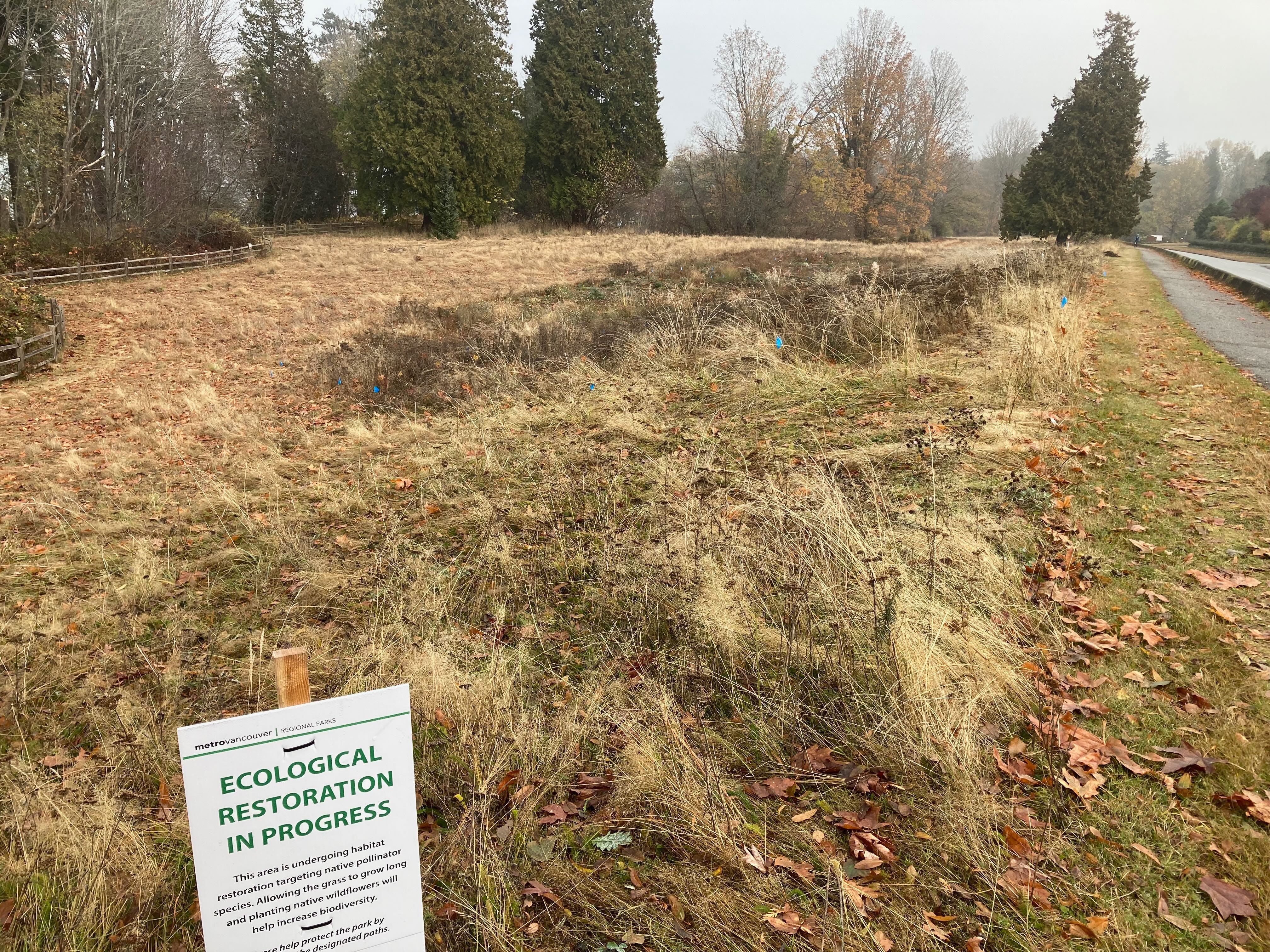
‘Acadia Meadows,’ is actually something rather different than an unmowed lawn alongside NW Marine Drive. It is a former Indigenous village with at least two millennia of history and human use. The restoration project acknowledges this fact in its project documents. Metro also works closely with the contemporary Indigenous rights holders, Musqueam Indian Band. The restoration, however, is less about returning to what was actually here. It is more about contemporary ideas of increasing ecological biodiversity in a much transformed urban landscape. The ‘past’ this kind of restoration brings us toward is one that ignores the significant effects of Indigenous land stewardship practices. Indigenous pasts are not directly overlooked nor are contemporary Indigenous communities ignored. Rather, ecological restoration models assume a marginal to non-existent Indigenous impact on the ecologies observed at the start of the colonial period. It is useful to consider these projects as less ecological restoration and more ecological enhancement.
The ‘meadows’ is not the only restoration project in this space. A creek restoration project was completed in 2018. ‘Salish’ Creek (also called Unnamed, Acadia or Hillary Creek) was ‘restored’ via a memorial gift to UBC. The creek project aimed to rework the creek to facilitate the return of salmon for spawning. Watershed restoration projects, like the meadow restoration, assume a kind of natural baseline, an idea that ecology persists in isolation from human hands (except for our negative effects that need to be mitigated). Yet, as Alaskan anthropologist Stephen Langdon has documented, many salmon bearing streams were extensively streamscaped by Indigenous stewards for millennia prior to industrial fishing, mining, and logging.2 It is very likely that the original Indigenous stewards of the creek actively shaped it to enhance spawning and harvesting potential.
Restoration grounded in history
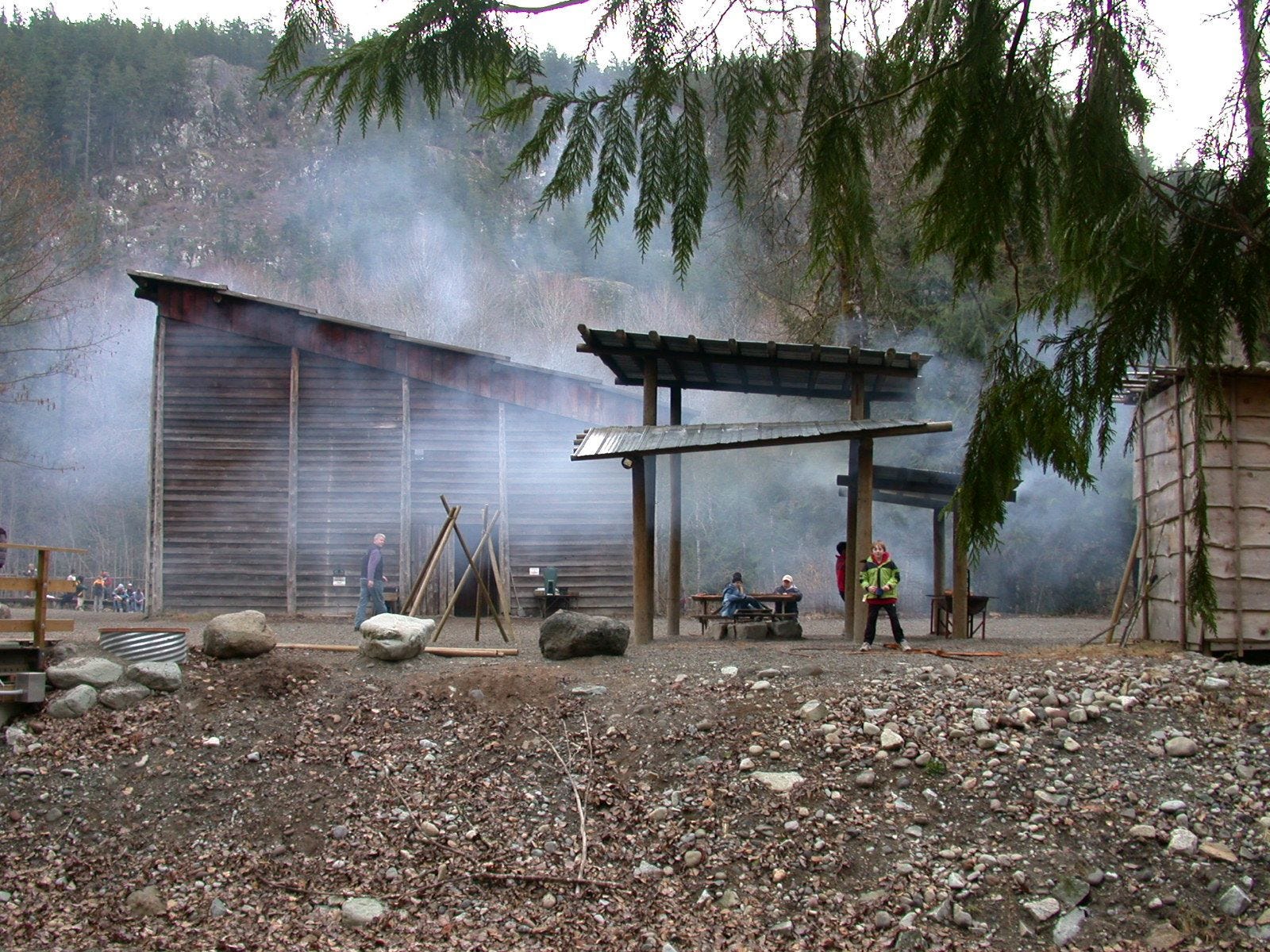
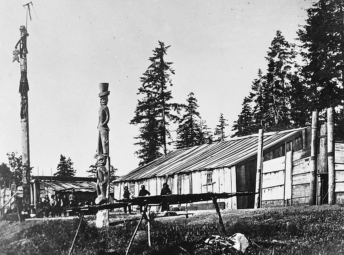
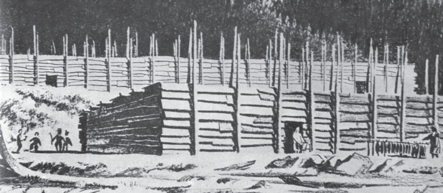
I’ve been thinking a lot about what this village would have looked and felt like when it was regularly lived in. My own life and work experiences are rooted in my Tsimshian family history in Laxyuup Gitxaała (Kitkatla Nation). There I have walked through ancient villages aided by the histories of my community and a sense of the aesthetic that informed our Indigenous built environment. While Musqueam shares many things with north coast Indigenous worlds it is like a foreign country to me even so. One of the most striking differences are in the buildings (but not the only difference). On the north coast we built large rectangular buildings with pitched gable roofs. Our houses had fronts, often painted with designs, that faced the water head on in ranked rows. Houses in the wider Salish world have a ‘shed’-style roof and could be several hundred feet long, running parallel to the shoreline.
These pictures, the 20th century Cheakamus Cultural Centre and an 18th century southern coastal village, give an idea of what the original village at Acadia Meadows could have looked like.
The 20th century archaeological reports and 19th century settler accounts suggest the village was no longer regularly occupied by the early 1800s. Though none of the documents discuss why, it is very likely the result of the small pox epidemic of 1782. Geographer Cole Harris draws on recorded First Nations’ oral histories of small pox and early settler journals to document the effects of this deadly disease in the Gulf of Georgia region - the effects of which Captain George Vancouver described on his voyage through the region (as quoted in Harris 19973):
“Vancouver began to find deserted villages, and human skeletons 'promiscuously scattered about the beach, in great numbers.' After local surveys in the ships' boats, similar reports came back from his officers; it seemed, Vancouver wrote, as if 'the environs of Port Discovery were a general cemetery for the whole of the surrounding country.' In some deserted villages, 'the habitations had now fallen into decay; their inside, as well as a small surrounding space that appeared to have been formerly occupied, were overrun with weeds.' There were also 'lawns' on eminences fronting the sea, which Vancouver thought might have been sites of former villages; in a few, the framework of houses remained. In Vancouver's mind, 'each of the deserted villages was nearly, if not quite, equal to contain all the scattered inhabitants we saw.’”
Cole Harris goes on to describe how, in the face of cataclysmic death and depopulation, the Indigenous communities found themselves reorganizing their communities, bringing survivors together, and creating a new social geography. It is likely in this period that the Acadia Meadows village ceased to be a regularly lived in place.
The late UBC archaeologist Charles Borden describes his guess at the age and length of occupancy of Acadia Meadows in a 1947 report. Borden used the stump of a 250 year old fir tree to suggest when the village was last used. He guessed that site was last lived in 400 years before the date of his report (i.e. about 1550 CA). He assumed that the village would need to sit unused for a century before the fir tree would start to grow. The logging in the area took place in 1885 - 60 years before Borden’s present. Add 60, 100 and the age of the tree and we get about 400 years before present. By a similar logic, based on Borden’s assumptions about the rate of soil deposition, Borden guessed the village was only lived in for about 300 years, so occupation was from 1250 to 1550 CA.
Borden was completely wrong. We know from work conducted under Gary Copeland’s direction that Acadia Meadows Village is at least 2000 years old. We also know that Borden’s assumptions about the site’s last occupation is equally flawed.
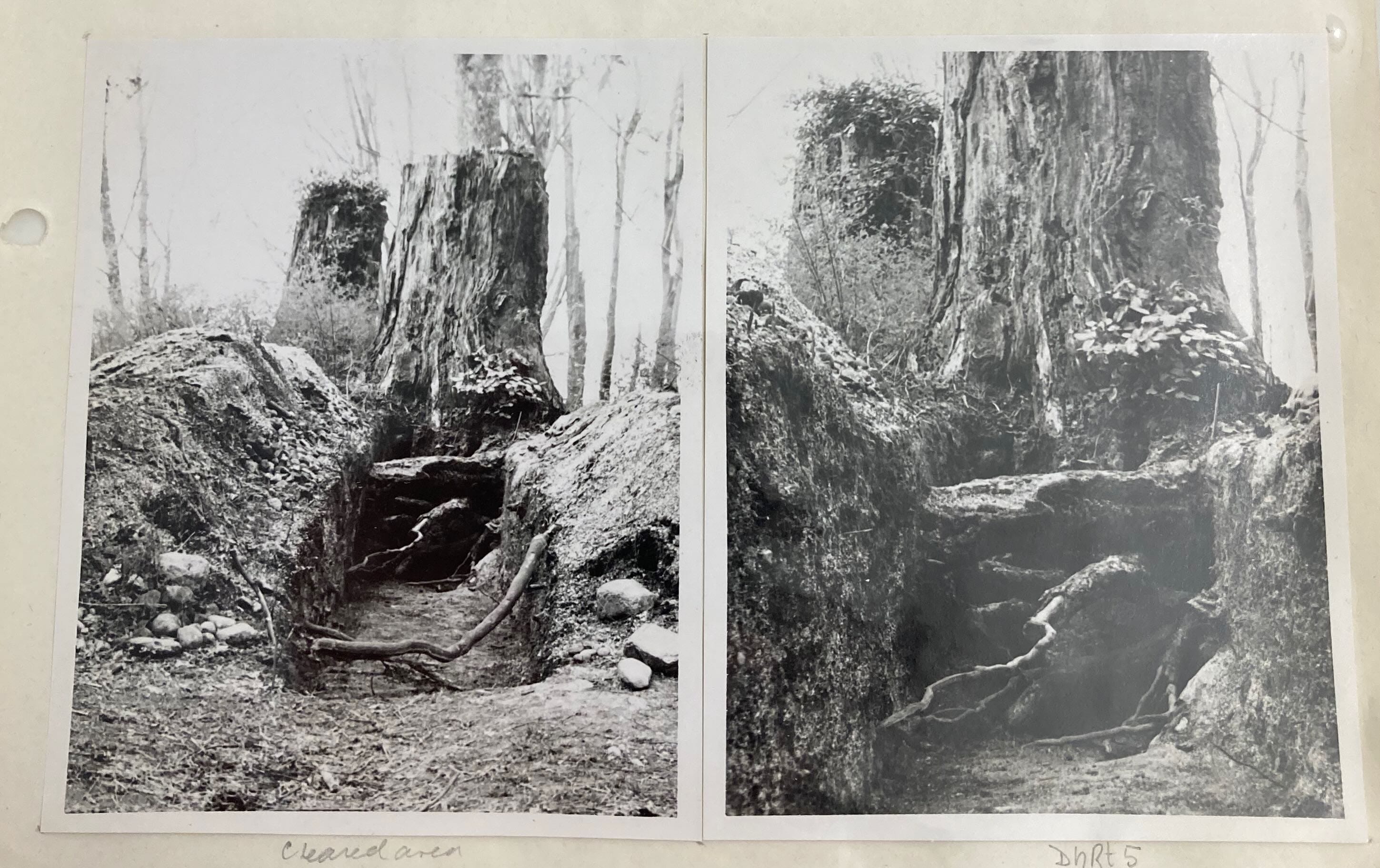
My experience in Laxyuup Gitxaała, were I have visited known cultural sites throughout our territory, points to the misjudgements Borden made. Many of Gitxaała’s older villages are filled with rows of tall firs and cedars, all about 200 to 300 years old (we have cored sample trees to determine their age). We’ve mapped the trees and find they roughly correspond to the dimensions and layout of the former longhouses that our ancestors had built. Using current sampling protocols4 we have carefully examined soil samples and have found evidence of human occupation from the start of the colonial period back three to five thousand years ago. Because our places were not disturbed by settlers, we are able to identify evidence of occupation practically to the present. The fir trees Borden notes very likely grew out of architectural features of the original Acadia Meadows longhouses. Borden even found archaeological evidence of what was likely two house posts at the western end of the meadow. This would be completely consistent with the long shed-like houses Indigenous peoples built in this region for most of their history here.
The village at t̕ᶿat̕ᶿəɬəm
The archaeology of the village at t̕ᶿat̕ᶿəɬəm focusses on the harvesting of fish, specifically herring (though also mentioned are four species of salmon and several species of cod and flatfish)5. More, however, would have been done here than fish herring. I can imagine the bustling activity in the village of 150 to 250 people as they went about their lives - playing, working, socializing. This would have been a multi-generational living space. There would have been lots of people of all ages (and their pet dogs) out and about.
The space in front of the village would have been cleared of trees. Behind the village would have risen a forest of trees 200 to 500 years of age, with some of the cedars approaching a millennia. In the spaces between the trees moss would have carpeted the ground. Where the light entered the forest canopy one would find tended patches of food berries and other harvestable plants. Deer, elk, bears, cougars, and a host of other animals would have shared the forest with people.
As the day passed a group of people may have been at a nearby stand of cedar pulling planks from the living trees. Others might be walking the local creek. They would check for, and clear, fallen debris. They would work on the stone walls that formed pools and platforms in the creek that jointly served to improve fish habitat and harvesting potential. Still others might be returning from across the point after visiting relatives living along the north arm of the stó:lō (river). Perhaps some are tending to forest gardens of qʷəʔapəɬp (crab apple) or looking after nearby berry patches of tłetłnátch (bunchberry), sháalʔəәłp (Saskatoon berry), t̕eqeʔəɬp (salal), and sk̓ʷəqʷcəsəɬp (red huckleberry). All of these plants were cultivated and maintained to ensure regular bountiful harvests over generations of use.
A visitor would most likely arrive off shore in their own boat. I can imagine my Gitxaała namesake, hagwil hayetsk, a young man in the gispuwada (blackfish) house of Ts’ibassa, arriving one morning after a long journey from the north. Such a journey may well have taken two weeks or more. Hagwill hayetsk and his companions would have had with them supplies for their journey and goods for trade. These would have been stored in watertight bentwood boxes. They would have contained things like our Tsimshian woven blankets of northern goats’ wool (with patterns coloured yellow, blue, black, and white), dried abalone and seal meat, berries preserved in oolichan grease, and chopped cakes of seaweed from our cold northern waters.
We wouldn’t have just come ashore, we would have stood off the village and called out, announcing who we were and asking the permission of the chiefs to land. People on shore would very likely have seen us much earlier as we made our way across the open water, perhaps as we passed round Cape Roger Curtis. They would have seen us headed their way. They would have noted the difference in our canoe, with its high carved bow painted red and black showing the crest of our house in designs unfamiliar in this village. They would understand we were travellers who wanted to be seen as we approached.
Our peoples were seasoned travellers with the skills and knowledge to facilitate trade and travel. In those days we would have been multi-lingual. I think of Hagwilget elder Donald Grey being interviewed in the early 1960s by UBC anthropologist Wilson Duff. Grey began by apologizing to Duff, stating that, unlike the old people, he could only speak eight languages. In each of our communities we had people who spoke many languages enabling communication across a great diversity of peoples. This would not have been the first time our people had travelled south, we were long distance traders who regularly travelled the entire Pacific coast. Our histories include accounts of regular trading relations across great distances, but also histories of individuals who left on odysseys of many years.
Once welcomed ashore, we would have pulled our canoe up beyond the high tide mark, and then joined our hosts in their home atop the 20m bluff above the beach. We would have been brought inside the longhouse to an earthen floored space with a fire in the middle. The meal served to us would have displayed the richness of our hosts’ labours managing and stewarding the environment within which they lived. Their labours would have built the ecology of the area surrounding the village at t̕ᶿat̕ᶿəɬəm. It was an ecology far more diverse than the current field of European grasses and brambles, and the scattering of indigenous plants now in evidence in Acadia Meadows.
Restoration as currently practiced might more aptly be thought of as ecological enhancement, not restoration. The current Acadia Meadows project is designed to increase habitat for pollinators, which would have a net positive effect in our world. That is not an act of restoration though. Restoration grounded in history would envision old growth trees, cultivated forest gardens, tended berry crops, and streamscaped creeks. Actual restoration would acknowledge the hours and years of labour and knowledge involved in creating the ecology settlers arrived into.
We will examine the specifics of the Acadia Meadows project in more details in a follow up story.
For those interested in reading more, see: Stephen Langdon’s chapter in TEK & Natural Resource Management, 2006, or; my own chapter, “The Disturbed Environment: The Indigenous Cultivation of Salmon,” in Keystone Nations, 2012
Harris, Cole. 1997. The Resettlement of British Columbia : Essays on Colonialism and Geographical Change UBC Press.
Borden used soil sieves of 6.35mm, today we start with 1.0mm sieve and identified shell and bone recovered from 2mm and above. Borden’s work was biased toward larger fauna. But he also describes how Acadia Meadows was significantly disturbed by settler use since 1865. First clear cut logging, then theft of topsoil, continuous dumping of garbage from local residents, the children’s camp that was built in the 1920s, and then used as a parking lot for beach access. Borden reports no early colonial objects in his research, but given the disturbance of the top layer of soil that is to be expected.
See the MA thesis by Wendy Unfreed (1989). A Faunal analysis of the Point Grey (DhRt5) site, Vancouver, B.C. (Unpublished master's thesis). University of Calgary, Calgary, AB. doi:10.11575/PRISM/21677 http://hdl.handle.net/1880/21796; Gary Coupland (1991). “The Point Grey Site: a Marpole Spring Village Component.” Canadian Journal of Archaeology / Journal Canadien d'Archéologie , 1991, Vol. 15 (1991), pp. 73-96. Charles Borden (1947). Preliminary report of the archaeology of Point Grey, British Columbia. Manuscript on file, Laboratory of Archaeology, University of British Columbia.