

Mapping with Photographs
Mapping with Photographs
I see the shapes I remember from maps...

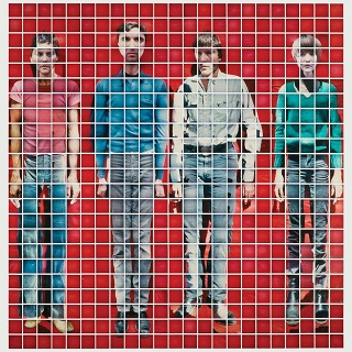
Back in 1978, Talking Heads released their second studio album “More Songs About Buildings and Food.” The cover art was a composite of 529 close-up Polaroid pictures of the band. I’ve linked to the Wikimedia page:
https://upload.wikimedia.org/wikipedia/en/7/75/TalkingHeadsMoreSongsAboutBuildingsandFood.jpg
You can see that there’s a lot of lens distortion and a slight variance in exposure in between each of the images. But if you know what the band looks like (or humans in general) you are able to recover enough information to recognize David, Tina, Chris and Jerry. Because the pictures were all close ups, the real composite image was probably close to life size.
Damn that television, what a bad picture
In 2003 I took a trip to the Grand Canyon. I wanted to get some use out of my brand new Canon Powershot S40 digital camera. And oh boy I did! Not only did it take great high resolution 4 megapixel pictures, the memory card stored hundreds of them. And when it filled up, no problem! Just copy ‘em off to your PC’s hard drive! Or heck, just carry a extra cards, they don’t take up much room. For someone coming from 35mm still photography, with only 24 images on a roll of film, and analog video that looked pretty bad even under the best conditions, this really was indistinguishable from magic.

While I was there I had a chat with someone capturing the sunrise with an 8X10 negative camera. This camera looked like one of the original glass plate cameras that predated nitrate and cellulose film. It was big, bulky and had he had to hide under a hood to set up the plate. He was going to make a very large print of the scene. This reminded me of a story I read about Kodak’s Colorama advertisement, on display in Grand Central Station from the 1950s through the 1980s. Kodak would commission photographs using extremely large format cameras and elaborate printing systems to make billboard sized slides that were displayed for a few weeks, covering all manor of subjects. Unfortunately I never got to see a Colorama, but I can imagine it left quite an impresion.
When I got home I went through my vacation pictures, and tried to print out a few. At 4MP they looked pretty good on an 800X600 computer display, but when printed out on 8X10 paper they really looked really bad. If you stood back far enough they were fine, but as soon as you got close you could see all the pixels and detail was just a blob. That’s just the way it was at the time, and so I (and everyone else) quit printing photos.
A few years and a few cameras later I had upgraded to a 12 MP DSLR. This could now produce a fairly good 8X10 print, especially when printed from a commerical printer. I ran it through its paces on a road trip through California.

That’s getting better. Much more detail, less compression, a larger sensor gathering more light. An improvement for sure but still not able to capture the grandeur of the scene as I saw it in real life. I began to wonder if there was a way to make a mosaic of prints that could create a life-sized print of a scene like the Grand Canyon or a cliffside view of the Pacific.
As it happens I wasn’t the only one. I came across this really interesting program called huge-in. It was one of the early photo stitching programs that could be used to make a panorama from several overlapping images. I started playing around with it and pretty soon had a set up that used a computerized telescope mount and some custom software to take dozens of pictures in a grid pattern that could be stitched together later. I dragged this rig around the southwest for a while, taking pictures of some pretty interesting stuff. And I could finally get that big print, although probably cheaper to just drive there and look.

You can't see it 'til it's finished
The problem was that it took far too long to take extremely detailed pictures. The Hoover Dam shot was taken with a telephoto lens and was several dozen pictures. It also put a lot of wear on the mechanical shutter, so I thought it best to not continue the experiment, at least not until the technology caught up.
Fast forward 10 years and 6 iterations of Moore’s law. Now we have extremely fast, small cameras (that fly too!). Computers that can easly process hundreds of images into gigantic photos. Not only that, but the cameras are able to log where and when a picture was taken to within a few inches, anywhere on Earth. This opens up a few interesting possibilities. Instead of using long telephoto lenses, why not just fly really close to a subject? Instead of trying to cram more and more megapixels into a sensor, just scan a scene with a drone and stitch the pictures together later. As long as the subject is mostly static and the light is somewhat consistent it should produce better results than a “big glass” camera. Not only that but because the drone can maneuver around the subject it opens up possiblities for 3D images as well.

Using a drone and automation it becomes very easy to take hundreds of close up pictures. The picture above was created from 340 individual images. Why so many? Why not? The drone’s doing all the work.


I have found the line and its direction is known to me
Of course now that it’s easy, everyone’s getting into the act. And like most things that start out as a cool hack, as more people use the tools they come up with additional features. Accuracy got better and pretty soon it was possible for software to correct for lens distortion, GPS position errors and the software itself. With corrected input data the images produced could be accurate to a few millimeters. In fact the orthophoto above is relatively accurate to 1.4 centimeters, and I wasn’t even trying. However the “GPS” accuracy (where the software says the image is on Earth) is only +/-2.8 Meters, so I wouldn’t use it to lay out a fence on a property line!
So what can we do with all this? Well, print out really big pictures for sure. But also import the files into CAD programs, inspect buildings and other infrastructure, and make measurements without having to climb up on the roof with a tape measure. And if we have a surveyor come out ahead of time and give us the location of a few specific points on the ground ahead of time, we can get that GPS accuracy down to a few centemeters, if the surveyor does a good job.

The 2D scan of the house above is a composite of 720 still pictures taken from an altitude of about 40 feet above the ground. This was a manual flight with a 3 second intervalometer running on my DJI Mavic 3, which has a 20MP camera. The house in the middle was the subject, and the mapping software does a pretty good job of making an accurate picture (relative accuracy is 0.2cm over the house). But this isn’t just stitching a bunch of pictures together. The software will create an original image by comparing all the pixels in all of the images and triagulating where they are from where the pictures were taken. Directly over the property there are many pictures with overlap. But as you can see the neighboring house looks a little wobbly because the software didn’t have enough overlap to make a useful image. Also you can see the street at the top is wider than the street in front of the subject property too. It really shows when compared to the Google Maps satellite image.

Notice how the sidewalk on the left is almost in line with the Google satellite but on the right is completely off. Again, that’s OK because I wasn’t trying to map the sidewalk. But it does show that the old adge of garbage in, garbage out still applies. Having good ground control points and GPS correction data will fix many of these problems, as well as having lots of good overlap.
And you may ask yourself, well, how did I get here?
So anyway, that’s how I got from wanting a big print from my Grand Canyon trip to taking hundreds of pictures of buildings (and food). Sadly, I still can’t take that lifesize picture of the Grand Canyon, because no one can fly a drone at the Grand Canyon without a permit -and no one gets a permit. But that a topic for another post…