

Maps of fictional places
Maps of fictional places
I could probably draw you a map of Upper Wheatley, but I haven't

Last month Simon K Jones1 asked his readers whether they liked fictional maps. There’s a certain sort of fantasy novel that is obliged to include at least one map — the world, the streets of the main city, the grasslands in relation to the sea — but apart from the occasional historical novel that adds a map of medieval Prague to aid your understanding of distance and amenities, that’s probably the only place you’ll come across a map as a reader of fiction.
I like a good fictional map, but then I also spend ages looking at the maps you get in history books showing the extent of the Roman empire at different crucial points in the past, maps of bird populations in the UK, 19th century maps of areas I know well. Maps can only enhance a book, for me. I understand that not everyone appreciates or can make sense of them, so as long as a reader can happily pass over the map and still follow the story, that seems fine.
As a writer, I realised I use maps and plans a lot, even if I don’t always draw them. If I said someone turned left from their street onto the main road, then later on I said they turned right but they’re making the same journey, that’s going to jar an observant reader out of their immersion in my fictional world. It will also really annoy me when I eventually spot it.
Sometimes it doesn’t arise — flash fiction or a short story contained in one location for instance, or focusing on interiority or dialogue. We never need to know if the kitchen opens into the living room or if there’s a hallway between, or whether the character who leaves to wash their hands has gone upstairs to a bathroom or a few steps away to a downstairs toilet. Any longer piece of fiction, or anything that requires it to be clear whether someone would have had to pass this object before leaving, or whether they could be seen from the street while they were opening the shed, and the writer needs to have a good idea of layout.
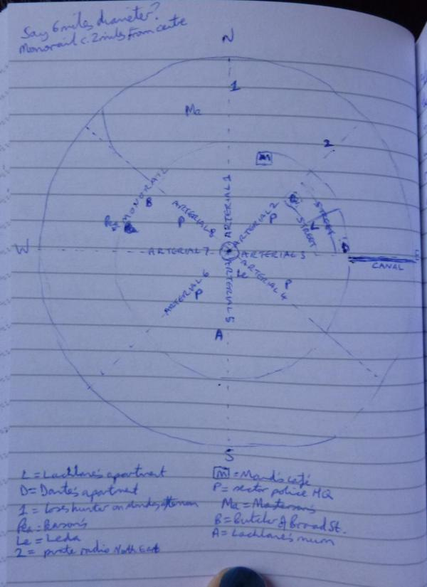
When I was writing the sci-fi/crime novel I mentioned last week (Lachlane’s Centrified City), I drew myself a quick sketch map of the city and marked a couple of key places on, then added more as I needed them. I did that because I was finding it hard to keep the street-plan clear in my head and in this case it mattered: would the detective choose to go to the records office (which is not actually marked on the map but it’s right in the centre) or to see Maud? To return to Masterson’s, or question the pirate radio crew? Given that she has to get around entirely on foot due to fuel shortages, she’s going to plan her next moves partly around the most efficient route.
The map also helped me work out rough timings (it ought to take twice as long to get here as it does to get there), likelihood of bumping into someone, and the characteristics of each neighbourhood. How do you add detail like ‘Masterson's was about three miles from home if I could hop from roof to roof in a straight line. On the ground, I had to travel through a tangle of streets off Arterial One’ if you haven’t got a map?
On the other hand with my audio sitcom Lee-Ann’s Spare Fridays I haven’t drawn anything on paper because the recurring interior locations and the village it’s set in are all clear enough in my head.
I was writing a script a few months ago and I thought, what if Lee-Ann’s gone to the Co-Op and left Gina in the flat, then tries to attract Gina’s attention from the street — then I realised you can’t see the Co-Op from Lee-Ann’s flat. Maybe from her bedroom if you pressed your face against the glass, and probably from the stairs, but not from the living room/kitchen where Gina’s waiting.
I can walk around Lee-Ann’s flat in my head, in just the same way as I can walk around my paternal grandparents’ house, last visited in reality in 1993. I couldn’t honestly give details of their wallpaper choices but I retain a vague impression of colour, and the floorplan is firmly etched in my mind, as is the placement of large items of furniture and prominent ornaments. I can remember the quality of light and the traffic noise in what was for several months in 1986, my bedroom. The lace curtains and the red glass bird on the living room windowsill are clear, but I couldn’t tell you what brand of washing up liquid they used or whether there was a dishcloth or brush beside the sink.
You get the idea.
I have a blurrier vision of Douglas’s flat on the floor below, and Gina’s house at the other end of the village is pretty disjointed, but I know my way around Upper Wheatley library. The village of Upper Wheatley itself is clear in places and a bit fuzzy in others. I’m not entirely sure how to get down to the bakery by the bridge from Lee-Ann’s street, but I can walk from her place past the library to the church with its neighbouring allotments. I know what the junction looks like, where you leave the village and join the main road, and I can locate the fictional village in a real area of the Yorkshire Dales that I’ve stretched a bit to make it fit.
None of this is written down or sketched out, it exists only in my head. So far that’s been fine, but as I approach the final planned episode I wonder if I ought to commit some of it to paper before it fades away, just in case I need to refer to it for a special episode or two. If I do, I’ll share it here. And I’ll try and make it neater and more legible than the Centrified City map I’ve shared above.
He writes Tales from the Triverse here on Substack, which is a fantasy/crime crossover serial I’m currently fairly near the beginning of but enjoying so far — worth checking out for anyone who particularly appreciated last week’s review roundup.